PROJECTS
INDEX
The federal ministry for Geoscience and Natural Ressources (BGR) holds an exploration license for polymetallic sulphides on behalf of the Federal Ministry for Economic affairs and energy (BMWi), issued by the International Seabed Authority (ISA). Since the approval of the licnese area in 2015, the BGR is obliged to conduct detailed exploration work within the license area southeast of Mauritius.
The biological work plays a central part of the BGR implemented INDEX project, that aims the exploration for polymetallic sulphides for the Federal Republic of Germany. The license area has an extent of 10,000 km2, splitted in 100 sulphide blocks in a size of 10 x 10 km each.
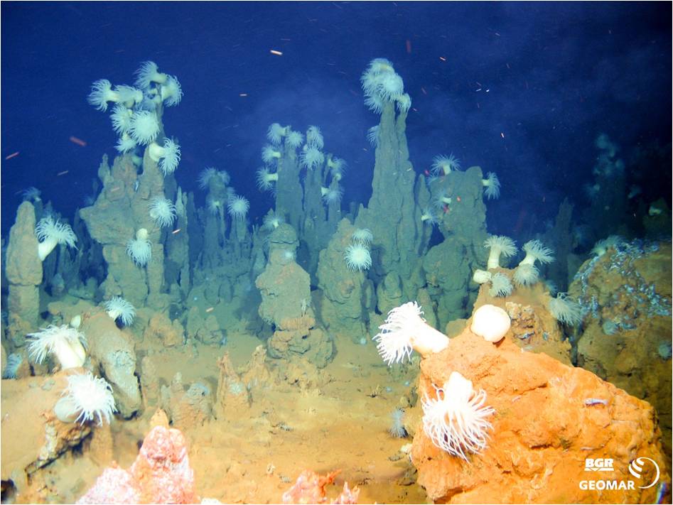
The goal of the biological studies within the INDEX project is the assessment and analysis of the pelagic and benthic communities within the license area north of the Rodriguez Triple Junction (southern Central Indian Ridge) and along the South East Indian Ridge. This includes studies on the species diversity, abundance estimations and the spatial distribution patterns of all benthic organisms. Based on the species richness, distribution patterns and their dependency on environmental factors we aim to identify the key structuring factors that maintain biodiversity of abyssal hydrothermal vent fields. Specific sampling and photograph- and video imagery collections are used to give explanations of the observed spatial distribution patterns of communities and their composition at active and inactive hydrothermal vent fields and the surrounding abyssal deep-sea plains.
Based on this data, communities will be defined and discriminated, connectivity of populations monitored and habitat maps created for the German license area. The comparison of communities from different stations aims for a better understanding of ecological and biogeographic patterns, that are driving biodiversity at greater scales. These environmental studies are conducted to identify key structuring factors that needs to be protected and to assign marine protected areas and facilitate a sustainable use of marine resources.
Further information
Homepage of the INDEX-project of the Federal Institute for Geoscience and Natural Resources (BGR)
MANGAN
Since 2010, biologists of the German Center for marine Biodiversity Research (DZMB) participate at all expeditions of the Federal Institute for Geoscience and Natural Resources (BGR) and collected roughly 50,000 samples of specimens from the benthic infauna, to study the diversity of the benthic fauna using molecular and morphological methods for the analysis. This task has moved to INES in 2019, who participates not only in BGR initiated expeditions, but also in cooperative expeditions with the DZMB studying the ecological consequences of potential deep-sea mining activities and the related disturbances of the fauna (JPIO, (www.jpi-oceans.eu); Discol, (www.discol.de).
So far, the analyzed sampled show a high abundance and species diversity. Surveys targeting the species richness and abundances of benthic organisms revealed the community structure within the manganese nodule belt of the Clarion-Clipperton Fracture Zone at greater spatial scales. Based on this data and results of several international research teams, the ISA assigned nine marine protected areas of a size of 400 x 400 km, incorporating 30 % of the total area of the manganese nodule belt. The protected areas were established to preserve the exceptional deep-sea ecosystems of the CCFZ and are refuge areas from which recolonization can take place after the extraction of manganese nodules through mining activities. In addition, INES and BGR are part of the European projects JPI Oceans Mining Impact, with the aim to address the impact of potential future mining activities in detail. Of particular interest are the consequences of the dispersion of suspended sediment plumes, which are a result of the manganese nodule collector tools. Data analysis shows, that low current velocities of 1-5 cm per second in varying directions are present in a depth of 4000 m. These current velocities and directions of the near bottom water masses are mainly driven by tides and surface winds.
Further information
Homepage of the MANGAN-project of the Federal Institute for Geoscience and Natural Resources (BGR)